Coastal managementCoastal Management is defense against flooding and erosion, and techniques that allow erosion to claim land
|
|
|
See Some Examples
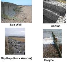
hardGroynes
Are barriers or walls perpendicular to the sea, often made of greenharts, concrete, rock or wood. Sea Walls Walls of concrete or rock, built at the base of a cliff or at the back of a beach, are used to protect a settlement against erosion or flooding. Gabions Boulders and rocks are wired into mesh cages and usually placed in front of areas vulnerable to heavy erosion Rock Armour Also known as riprap, rock armour are large rocks piled or placed at the foot of dunes or cliffs with native stones of the beach. |

softBeach Replenishment
This involves importing sand off the beach and piling it on top of the existing sand. Sand Dune Management Sand dune stabilization or sand dune management works using a number of different methods in order to prevent the loss of sediment on the beach. Beach Drainage Beach drainage or beach face dewatering lowers the water table locally beneath the beach face. |
RANGE LAND
Open country used for grazing or hunting animals.
Deserts
Tundra
Wet lands
Savannah
Shrub lands
Forests
Grass land
Forage Pasture
Forest make up 25% of land
Crop land makes up 10%
Urban is 3%
Ice, Rock and Barren Desert is 15%
Range Land is 47%
47% of the world is range land
36% of America is range land
53% of western America is range land
44% of Idaho is range land
All range land is owned by the people. People use it to for livestock production, wildlife habitat, water, minerals, and native plant products
1. In What part of the United States are most federal lands located? most range land is in the western United States. Rangeland covers about 50% of it.
2.Locate the area of the U.S., called “America’s bread basket” (named for the wheat and other crops grown there) which includes Kansas, Iowa, Nebraska, Missouri and Illinois. On what type of land is most of the wheat grown? The Great Plains / prarie
3. Which state has the most Indian reservations? Arizona
4. What agency of the federal government owns most of the land in Utah? Bureau of Land Management
5. What biome best describes the Utah lands indicated in yellow? a. savanna b. desert c. forest d. grassland
6. Along what geographical feature is most of Utah’s forest land located? The Great Basin
7. What two geographical features in Utah are owned by the Bureau of Reclamation? Uintah and Ouray IR
